Autonomous Drone Swarm Intelligence Systems and Coordinated Aerial Mapping Architectures
The rapid advancement of artificial intelligence, robotics, and autonomous aviation technologies has transformed the capabilities of modern drone systems. Traditional drones were primarily designed for individual operations controlled by human pilots, but the increasing demand for large-scale aerial monitoring, precision mapping, surveillance, logistics, and disaster response has led to the development of more advanced autonomous systems. Autonomous drone swarm intelligence systems and coordinated aerial mapping architectures represent the next evolution of aerial robotics, enabling multiple drones to work together collaboratively through AI-driven coordination and real-time communication networks. Inspired by the collective behavior of birds, insects, and biological swarm systems, these intelligent drone networks can perform complex tasks more efficiently, accurately, and autonomously than single-drone operations. From environmental monitoring and military reconnaissance to smart agriculture and urban planning, coordinated drone swarm technologies are transforming industries worldwide. As autonomous aviation systems continue evolving, drone swarm intelligence platforms are becoming essential for scalable aerial data collection, intelligent automation, and next-generation airborne operations.
Understanding Autonomous Drone Swarm Intelligence Systems

Autonomous drone swarm intelligence systems are collaborative networks of multiple drones designed to operate collectively using artificial intelligence, machine learning, and decentralized communication frameworks.
Swarm Intelligence and Collective Decision-Making
Swarm intelligence is inspired by natural systems such as ant colonies, bird flocks, and bee swarms, where groups operate cooperatively without centralized control. Drone swarm systems replicate this behavior through AI algorithms that allow drones to communicate, coordinate, and make collective decisions autonomously.
Each drone within the swarm gathers environmental information and shares data with neighboring drones in real time. This decentralized decision-making structure improves operational flexibility and allows the swarm to adapt rapidly to changing environments.
Collective intelligence enables drone swarms to perform tasks such as area scanning, obstacle avoidance, target tracking, and route optimization more efficiently than individual drones operating independently.
Autonomous Navigation and Flight Coordination
Modern drone swarm systems use autonomous navigation technologies powered by GPS, computer vision, LiDAR sensors, and AI-based flight control algorithms. These systems allow drones to coordinate movements precisely while maintaining safe distances and optimized flight formations.
AI-driven navigation platforms continuously analyze terrain conditions, weather patterns, and environmental obstacles to adjust flight paths dynamically. Coordinated flight management reduces collision risks and improves mission efficiency across large operational areas.
Autonomous coordination also enables drones to distribute workloads intelligently, ensuring optimal resource utilization and balanced energy consumption during missions.
Distributed Intelligence and Real-Time Adaptation
Unlike centralized drone control systems, distributed intelligence architectures allow each drone to function as an intelligent node within the swarm. If one drone experiences technical issues or communication failures, the remaining drones can reorganize and continue operations autonomously.
Real-time adaptation capabilities improve system resilience and operational reliability. AI-powered swarm systems continuously learn from mission data and environmental interactions to optimize future performance.
This adaptive behavior makes drone swarms highly effective in unpredictable environments such as disaster zones, military operations, and remote exploration missions.
The Role of Coordinated Aerial Mapping Architectures

Coordinated aerial mapping architectures are advanced systems that use synchronized drone networks to collect, process, and analyze aerial data for mapping, surveying, and environmental monitoring applications.
High-Resolution Terrain Mapping
Drone swarms equipped with advanced imaging systems can capture highly detailed aerial data across large geographic regions rapidly and efficiently. Coordinated mapping architectures combine imagery from multiple drones to generate accurate 3D terrain models and geospatial datasets.
AI-powered image processing technologies analyze aerial photographs, topographical information, and sensor data to create detailed maps for construction, urban planning, mining, and infrastructure development.
High-resolution mapping improves project accuracy while reducing the time and cost associated with traditional land surveying methods.
Real-Time Environmental Monitoring
Environmental agencies increasingly rely on coordinated aerial mapping systems to monitor forests, oceans, wildlife habitats, and climate conditions. Drone swarms can collect environmental data continuously across large ecosystems using thermal cameras, multispectral sensors, and atmospheric monitoring equipment.
AI algorithms analyze environmental patterns such as vegetation health, pollution levels, water quality, and land-use changes in real time. These insights support conservation efforts, climate research, and disaster prevention strategies.
Real-time monitoring capabilities enable faster responses to environmental threats such as wildfires, oil spills, and illegal deforestation activities.
Collaborative Data Collection and Processing
Coordinated drone networks distribute mapping and sensing tasks across multiple aerial units, significantly improving data collection efficiency. Each drone captures specific sections of the operational area while AI systems merge and analyze collected data centrally or through edge computing frameworks.
Collaborative processing improves scalability and enables faster generation of large-scale geospatial models. Distributed aerial data collection is particularly valuable for time-sensitive operations such as emergency response and military reconnaissance.
AI-powered aerial architectures also reduce operational redundancy by optimizing drone deployment strategies dynamically.
Key Technologies Behind Drone Swarm Intelligence Platforms

Several advanced technologies support the development of autonomous drone swarm systems and coordinated aerial architectures.
Artificial Intelligence and Machine Learning
Artificial intelligence is the foundation of drone swarm coordination and autonomous decision-making. Machine learning algorithms enable drones to recognize patterns, optimize navigation routes, and adapt to environmental changes dynamically.
AI systems continuously analyze flight data, sensor inputs, and communication signals to improve operational performance and mission efficiency. Predictive analytics also help anticipate weather conditions, battery limitations, and obstacle risks.
Machine learning technologies enhance swarm adaptability and allow drones to improve coordination through continuous learning processes.
Computer Vision and Sensor Fusion
Computer vision technologies enable drones to interpret visual environments using cameras, infrared sensors, and LiDAR systems. AI-powered vision systems support object detection, terrain recognition, target tracking, and obstacle avoidance during autonomous flights.
Sensor fusion combines data from multiple sources such as GPS, radar, thermal imaging, and motion sensors to improve situational awareness and navigation accuracy.
Advanced perception systems allow drone swarms to operate effectively in complex environments with limited visibility or rapidly changing conditions.
Edge Computing and Wireless Communication Networks
Drone swarms generate massive amounts of data during operations, requiring fast processing and reliable communication systems. Edge computing enables drones to process critical information locally instead of relying entirely on centralized cloud servers.
Wireless mesh networks allow drones to exchange data directly with nearby units, improving communication speed and reducing latency. These decentralized communication architectures enhance operational reliability in remote or communication-limited environments.
Efficient data processing and networking are essential for maintaining real-time coordination within large drone swarms.
Applications of Autonomous Drone Swarm Intelligence Systems

Drone swarm intelligence technologies are transforming multiple industries through advanced aerial automation and collaborative data collection.
Disaster Response and Emergency Management
Autonomous drone swarms play a critical role in disaster response operations by providing rapid aerial assessment and real-time situational awareness. Swarms can survey damaged infrastructure, locate survivors, and monitor hazardous environments more efficiently than manual rescue teams.
AI-powered drones equipped with thermal imaging and environmental sensors help emergency responders identify high-risk areas and coordinate rescue operations effectively.
Drone swarms are especially valuable during earthquakes, floods, hurricanes, wildfires, and industrial accidents where rapid aerial intelligence is essential.
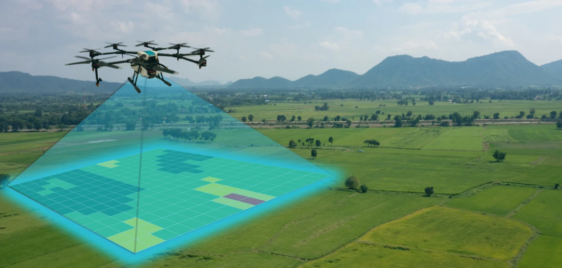
Precision Agriculture and Smart Farming
Agricultural industries use drone swarms for crop monitoring, irrigation analysis, pest detection, and precision spraying applications. Coordinated aerial systems can scan large agricultural fields quickly and generate detailed crop health maps using multispectral imaging technologies.
AI-driven analytics help farmers optimize fertilizer usage, water management, and harvesting schedules based on real-time agricultural data.
Precision agriculture improves crop yields, reduces operational costs, and supports sustainable farming practices.
Military Surveillance and Security Operations
Defense organizations increasingly deploy autonomous drone swarms for reconnaissance, border monitoring, and tactical surveillance missions. Swarm intelligence improves mission scalability while reducing operational risks for human personnel.
AI-powered drone networks can track moving targets, monitor strategic locations, and perform coordinated surveillance across large geographic areas.
Military applications also include electronic warfare support, communication relay systems, and autonomous threat detection technologies.


Gary Arndt operates "Everything Everywhere," a blog focusing on worldwide travel. An award-winning photographer, Gary shares stunning visuals alongside his travel tales.
Gary Arndt

Prev Post
Next Post